MyCoast: Rhode Island fotos aportadas por voluntarios de todo el estado, que suben a la aplicación imágenes de inundaciones localizadas. Estas fotos se vinculan con datos meteorológicos y sobre las mareas, lo que permite generar informes que ayudan a las partes interesadas —como organismos públicos, empresarios y residentes— a comprender los riesgos de inundación y a tomar decisiones fundamentadas para proteger mejor los barrios y las infraestructuras.
MyCoast: Rhode Island
¡Haz fotos de las inundaciones en tu barrio!




Cómo funciona

Añade tu foto o informe de «
»
Haz la foto a través de nuestra aplicación móvil (más abajo) o envíala desde tu navegador cuando vuelvas al ordenador.

Recuperamos
Datos de fondo
Nuestros servidores recogen información meteorológica y sobre las mareas para añadir contexto a tu foto.

Su informe «
»
sirve de base para la toma de decisiones
Los líderes y las organizaciones de las zonas costeras pueden utilizar tus datos para tomar mejores decisiones.
Hasta la fecha, los participantes en « Rhode Island » han enviado 6.647 informes con 13.383 fotografías.
Herramientas de Rhode Island
Utiliza estos botones para ver las fotos que ya hay y subir las tuyas propias


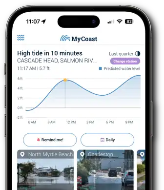
¡Enviar fotos a
es muy fácil con la aplicación
MyCoast!