Know Your Tides
High tide in New Jersey comes twice a day, whether you’re by the ocean, a bay, or a tidal river. With sea levels getting higher and sunny day flooding on the rise, you can maximize your summer fun and stay safe by knowing your tides.
Check Local Tides
- Search for a location or zoom in to select the nearest tide station.
- The chart generated under ‘Upcoming Tides’ will display the times and predicted heights for the next month of high and low tides. New to tide charts?
- Tide height is the height above Mean Lower Low Water (MLLW)—the daily low tide level averaged over a 19-year period. It doesn’t tell you how far up the shoreline the water will reach. In many places, even a small increase in tide height impacts many activities!
- The accuracy of predicted tides may vary depending on your distance from the tide station and local weather conditions.
Click on a Station
Selected Station: {{curStation.name}}
All heights shown relative to Mean Lower Low Water (MLLW): the daily low tide level averaged over a 19-year period.
Tides Today
■ Observed
■ Predicted water level
⬤ Report time
Upcoming Tides
(Scroll to see future days)
| Date | Time | Type | Height |
|---|---|---|---|
| {{(isNewSection($index) ? day.date : "")}} | {{day.time}} | {{day.type}} |
{{toFtInches(day.pred)}} |
Couldn't retrieve current tide data. Please check internet connection.
(Click here for full tide details from NOAA Tides & Currents)
Use local tide predictions to plan your time on the coast. Did you know that…
- Tracking tide heights and times is essential to planning a perfect day anywhere on the water.
- The best clamming happens at low tide! Head out when the tide is approaching low to clam through low tide and part way through the incoming tide, depending on the depth of the area.
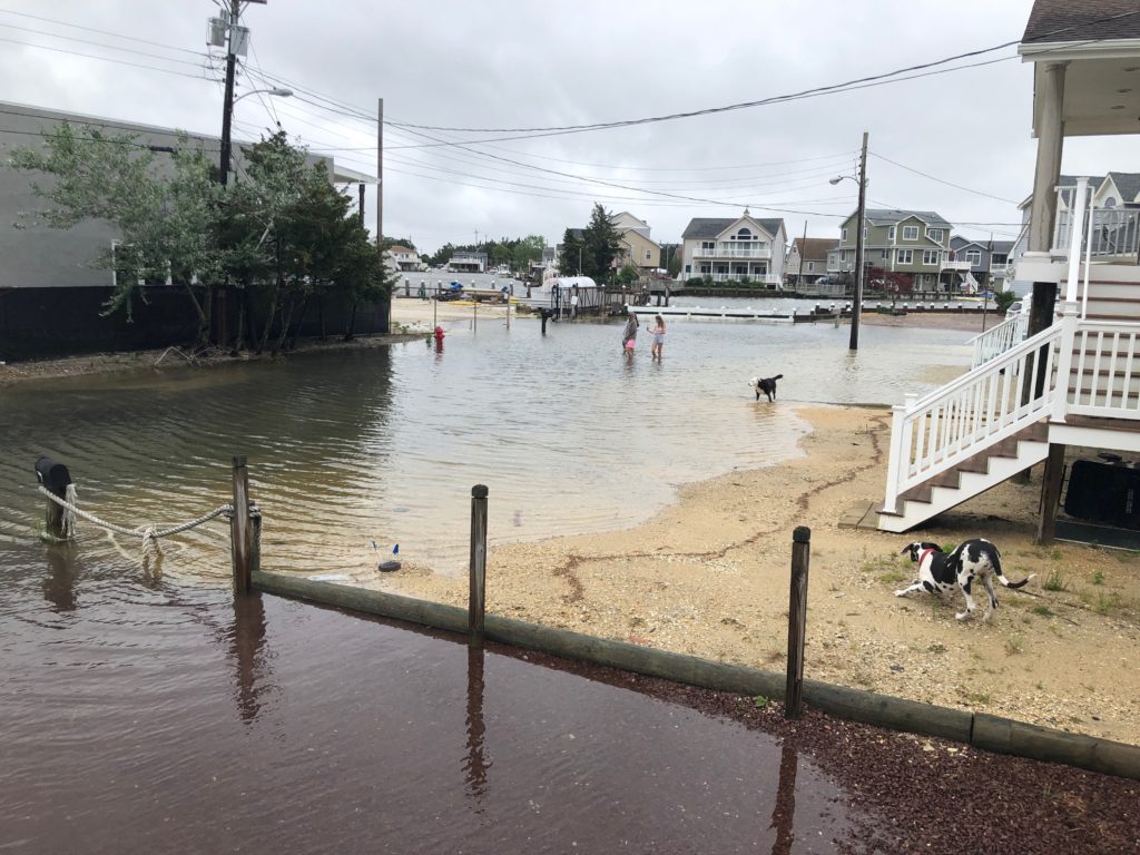
- Tidally driven floods—also known as sunny day floods—are becoming more common. Knowing when these tides are predicted will help you stay dry and safe.
Be Tide Smart
Sea levels are rising faster in New Jersey than other parts of the world, and tidal flooding is here to stay. Being tide smart can make or break a trip to the water—or your daily commute. Here’s all you have to do:
- Check local tides here or by downloading the MyCoast App for tide info on-the-go.
- Upload photos. We want to see your pics of high tides and their impacts on our beloved coastal places. Your participation will help others plan their days on the coast and document tidal impacts in New Jersey.
- Sign up for local flood alerts on Nixle to get emergency advisories texted to your phone. For more robust flood alerts by email, sign up for the Stevens Flood Advisory System.
- Be prepared before floods happen. Know your evacuation route and leave when told. Do not drive, walk, or swim through floodwaters. Remember: Turn around, don’t Drown!
- Know your risk. New Jersey tides are getting higher and storms are more intense. Learn more about your future vulnerability to sea level rise with NJFloodMapper.org. Remember that most homeowner’s insurance doesn’t cover flooding, leaving your home or business unprotected. Get flood insurance.
- Have an emergency kit and a family plan. A plan and an emergency kit help you to be ready for the unexpected and reduce your stress in a flood—or in any other kind of emergency. Learn more here.
Frequently Asked Questions (FAQ)
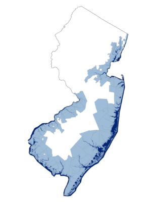 All of New Jersey’s coast! That includes our border with New York—through the Passaic and Hudson Rivers—Raritan Bay, from Sandy Hook to Cape May, along Delaware Bay, and up the Delaware River to Trenton. There are 231 municipalities in 17 counties that are impacted by tides.
The tide influences many outdoor activities, including boating, hiking, fishing, beach going, and wildlife watching. Knowing your local tides helps you maximize your fun and stay safe. In many places, tides can impact roads, homes, and businesses. Being tide smart will empower you to stay safe and enjoy all that New Jersey’s coasts have to offer. Did you know that….
- Tracking the tide’s height and direction is essential to planning a perfect day anywhere on the water.
- The best clamming usually takes place at “negative tides” when the low tide is BELOW Mean Lower Low Water (MLLW). Head out when the tide is approaching low to clam through low tide and part way through the incoming tide, depending on the depth of the area.
- Tidally driven floods—also known as sunny day floods—are becoming more common. Knowing when these tides are predicted will help you stay dry (when you want to be) and safe.
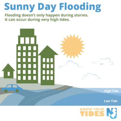
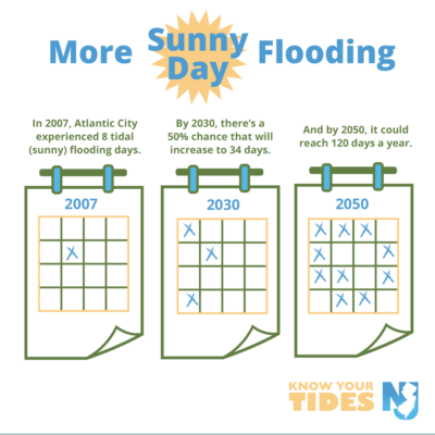
Sunny day flooding, also called high tide flooding or nuisance flooding, occurs when especially high tides push water into low-lying areas. These floods are not driven by rain or storms and can strike without a cloud in the sky!
Sunny day flooding is becoming more common in New Jersey. Atlantic City currently experiences sunny day flooding eight times a year on average. By 2050, that number is expected to go up to 24 days, and there’s a 50% chance it could hit 120 days.
- Sign up for flood alerts by text at nixle.com or by email through Stevens Flood Advisory System. If your zip code does not get Nixle alerts, contact your local government to find out what emergency alert service they use.
- Make sure you know your evacuation route so you know where to go when flooding strikes.
- If you are under a flood warning, follow the ready.gov flood guidelines. Never try to walk, swim, or drive through flood waters, and evacuate if you are told to do so.
- If you own a home or business in a tidal area, you can use NJFloodMapper to understand your flood risk. If you are at risk, consider purchasing flood insurance and make a flood plan for your household.
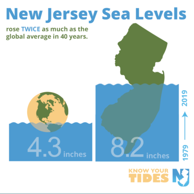
Sea level rise is happening faster in New Jersey than in other parts of the world, and precipitation is worsening.
Sea Level Rise
- In 40 years, New Jersey sea levels rose almost twice as much as the global average (8.2 inches vs. 4.3 inches).
- There is a 50% chance that New Jersey sea levels will meet or exceed 0.8 feet by 2030 and 1.4 feet by 2050.
Sunny Day Flooding
- Sunny day flooding is becoming more common.
- Atlantic City currently experiences sunny day flooding an average of eight times a year. By 2050, that number is expected to go up to 24 days, and there’s a 50% chance it could be as frequent as 120 days per year.
Precipitation and Storms
- Storms are anticipated to become more frequent and severe due to climate change.
- Annual precipitation in New Jersey is expected to increase by 4% to 11% by 2050.
- The size and frequency of floods will increase as annual precipitation increases
- Droughts may occur more frequently due to changes in precipitation patterns.
See the 2020 New Jersey Scientific Report on Climate Change for more information.
For more information about tides and water levels, you can explore these resources.
Climate change is anticipated to cause changes to our precipitation and more frequent and severe storm events, including both rain events and coastal storms. The size and frequency of floods will increase as annual precipitation increases. Drought-like conditions may also occur more frequently due to changes in precipitation patterns. See the 2020 New Jersey Scientific Report on Climate Change for more information.
The Know Your Tides flood awareness campaign was developed with support from Roca Communications, a social impact firm that provides communications, strategic planning, and group process services for coastal environmental programs and projects nationwide.